Location: Assabet River National Wildlife Refuge
Managed by: US Fish & Wildlife Service
Trail: Fisher Loop
Date: 9/19/17
Distance: 3.82 miles
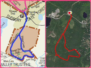
Trail Map
Clearly, the map was easy to follow!

Today was rainy and gloomy, which sometimes is the best hiking weather... No other hikers, and the mist in the trees is gorgeous! It's been a tough week and I wanted a short, easy, mindless hike. This fit the bill. It's completely flat, and the trails are very easy to follow. There are TONS of bugs here (I'm sure this depends on the time of year -- I've been to this location twice this month and both times, even in the rain, wore a net over my head). This hike begins with crossing the pretty busy road, but once you're on the other side, it's really peaceful.
Summary:
- Set a pin for the entrance you want in your GPS. This particular entrance is right next to the fire station. On the site with the trail map, you can read about the different options. You can also go to the US F&W website for updates on certain parts of the refuge that are closed for rehabilitation efforts.
- No dogs -- lots of signs posted on the trails (due to its status as a wildlife refuge)
- Highly recommend a bug net for your head. They're just so persistent.
Right around the beginning of the hike.
I didn't know there would be multiple bodies of water on this hike (they're not on the map!), and it was a really nice surprise.
Some of the trail is paved.
Bug life.
Some of the trail is sandy...
Came across some old railroad tracks <3


No comments:
Post a Comment