Monday, July 17, 2017

Harold Parker State Forest

Location: Harold Parker State Forest
Managed by: DCR
Trail: Brackett Pond Trail
Date: 7/17/17
Distance: 2.14 miles

This hike didn't go *exactly* as planned, but wasn't totally disastrous:


I love this park. I did a much longer hike here a few weeks ago. That hike was much easier to follow in terms of trail markers. The numbers this time were less helpful, because I sometimes couldn't find them. Ultimately, it didn't matter, because you can just follow the outline of the pond. I think I hugged the pond more closely than the trail on the map does -- but there were always several trail choices right by each other.

Summary:
  • Pay attention to where you are relative to the pond, and don't worry about which trail you're on
  • I just read that there is a parking fee at some of the parking areas -- I didn't see a kiosk where I parked, but I have a DCR pass so I wasn't looking for one. 
  • Dog friendly!

Audiobook life.

Playing on the rocks...


Weir Hill


Location: Weir Hill
Managed by: TTOR
Trail: Stevens Trail/Alewife Trail/Cochichewick Trail/Edgewood Farm Trail (Yellow Loop)
Date: 7/17/17
Distance: 3.3 miles
Trail Map

Hike went exactly as planned:


The trail map for this reservation was just updated in March, so it's super nice and extremely easy to follow. The colors for the different trails are marked very clearly along the way. There are trail maps at the parking area and full trail maps are posted periodically throughout the hike.
I saw ghost pipes (Indian pipes/ghost plant) twice on this hike! My first time ever seeing them outside of pictures. The hike was quite pretty, but this was by far the most remarkable part of it.

Summary:
  • Dog friendly!
  • Wear sunscreen. The segment around where the map says "Scenic View" is super exposed, as you can see in the hybrid photo above. 
  • Easy to follow trails

Crow pose is really hard when you're covered in sweat and crazy humidity!

Had fun playing on the boardwalks. 

No swimming in Lake Cochichewick -- it's the main supply of drinking water for North Andover. However, "manually propelled" boats are allowed!

First sighting of ghost pipes...

Up a little closer... 


The sun coming through the trees was crazy beautiful. 

Super lush and green!

I wasn't so crazy about this section of the trail. This is near the "scenic view". 

Second ghost pipes sighting!

Sunday, July 16, 2017

Ward Reservation


Location: Ward Reservation
Managed by: TTOR
Trail: Ward Trail/Bay Circuit Trail/Sanborn Trail
Date: 7/16/17
Distance: 3.33 miles
Trail Map

Here's what I planned vs what I did. Success!


After hiking at Ward Reservation a few days ago, I really wanted to get back and explore more trails. Honestly, I was just *really* curious about what is marked on the map as "RUBBISH MEADOW"!! It turned out to be a really pretty... lake? pond? swamp? ... body of water (as you can see in the above satellite photo & below in my hike pictures). Based on this hike and the hike I did earlier in the week, I've determined what I think is an ideal hike for this reservation -- if I could only go once, this is what I would do:


Summary:
  • Parking fee: $5 (or TTOR annual membership)
  • Dog friendly
  • Trails are very easy to follow

Ran into some hikers with a really cute dog. This made me very happy. Clearly.


"Rubbish Meadow"


Most of the signs were clear. Some need to be replaced, but as you can see, the color coding on the maps is obvious on the trees.


Thursday, July 13, 2017

Ward Reservation


Location: Ward Reservation
Managed by: TTOR
Trail: Bog Trail/Graham Trail/Vetter Trail/Elephant Rock Trail (Yellow & Blue Trails)
Date: 7/13/17
Distance: 4.71 miles
Trail Map

Here's what I planned vs what I did. Success!


I had read that the Bog Trail was not to be missed. It's just .3 miles long, so I was a little skeptical. But... IT'S NOT TO BE MISSED. Admittedly, I'm *pretty* into boardwalk trails and generally think they're magical. But this one is extra great -- it's my second favorite (behind the one found at Ponkapoag Pond). My friend agreed. It's not just me. The other trails were beautiful and fun as well, but that's definitely the gem of this reservation. The trails are clearly marked with colors (yellow, blue, and red). There are maps available at the entrance to take with you while hiking. There are also a number of maps at various points along the trails showing where you are.

Summary:
  • Parking fee: $5 (or TTOR annual membership)
  • Dog friendly
  • Trails are very easy to follow


Oasis at the end of the boardwalk!

We think this is Elephant Rock? It's pretty small. 


How do the solstice stones work? We weren't sure. 

Wednesday, July 12, 2017

Discover Hamilton Trail


Location: Patton Park, Harvard Forest, Appleton Farms Grass Rides, Pingree Reservation, Bradley W. Palmer State Park, Black Oak Farm, Collarbone Field, Brick Ends Farm, Myopia Schooling Field
Trail: Discover Hamilton Trail
Date: 7/12/17
Distance: 15.21 miles
Info & Trail Map

The mapped hike vs mine...


So, this hike is supposed to be 10.4 miles. I was ready for that. I wasn't quite ready for 15+ miles in roughly 90 degree heat with extreme humidity and intermittent rainfall. I mean, I guess I was ready, because I did it, but by mile 13, I just wanted to be *done*. I'm not too sure where all the extra miles came from. More than one extra mile came from me spending over 45 minutes trying to figure out where the trail resumed on the other side of Highland Street. As it turns out, you just need to step over all the construction tape and brand new "NO TRESPASSING" signs -- and then you'll be right back on the trail again. Hopefully this isn't the case for long... I'm sure it's very temporary and was just bad timing for me. The rest of the extra miles were probably just other parts where I accidentally veered off for a little bit.
Mostly, the trail is easy to follow. There are markers on trees, and there were only a few times where I felt it wasn't totally clear. I did not encounter another hiker at any point during these 15 miles -- just once, I saw someone playing with their dog at a beach the trail passed.
This hike was fun, but if I did it again, it would probably be with a friend and a picnic lunch.

Summary:

  • Bring a printed copy of the map, or a battery pack for your phone in case it dies (if you use tracking apps and other battery-sucking stuff). 
  • Bring sunscreen. Reapply often. There are some wide open fields you'll cross. 
  • Dog friendly!


I accidentally started off on the railroad tracks, instead of on the path just to the right on the other side of the trees. Took me to the same place... Just had to go through a little craziness pushing my way through trees to get back on the right path eventually. Picture is fuzzy because of the extreme humidity.


Much of this follows the Bay Circuit Trail. Here are the two markers to look for (be careful, they do diverge sometimes).


This is why you should *definitely* wear sunscreen and reapply often.


But most of the trail is more like this.

Tuesday, July 11, 2017

Stony Brook Reservation


Location: Stony Brook Reservation
Managed by: DCR
Trail: East Boundary/Bearberry Hill/Stony Brook Path Loop
Date: 7/11/17
Distance: 3.38 miles
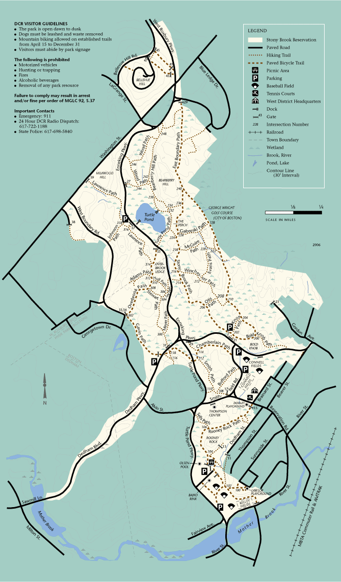
Trail Map

Here's the planned hike & what I actually did... Success!


The East Boundary Path is mostly paved, which I'm not crazy about. Buuut it was beautiful and worth it. A good introduction to this reservation. There are lots of smaller paths that are even prettier and would be fun to explore. Turtle Pond was the best part of this hike -- it's gorgeous and there's a dock out over the water. I played on that for quite a while in the rain this morning! The trail map is very easy to follow -- the names of the trails aren't often posted, but all the numbers seen on the map are clearly marked on trees.

Summary:
  • Easy to follow trails
  • Dog friendly
  • No trail maps posted at the parking areas I saw -- important to save the map on your phone or print before going
I almost immediately found a fun fence to hang from :D 

hi do you like spiders?

watching an airplane


Beautiful path... But paved.